Why hurricanes are getting more powerful—more quickly
Warm waters are like fuel for hurricanes, and hotter ocean temperatures are fueling explosive growth in storms.

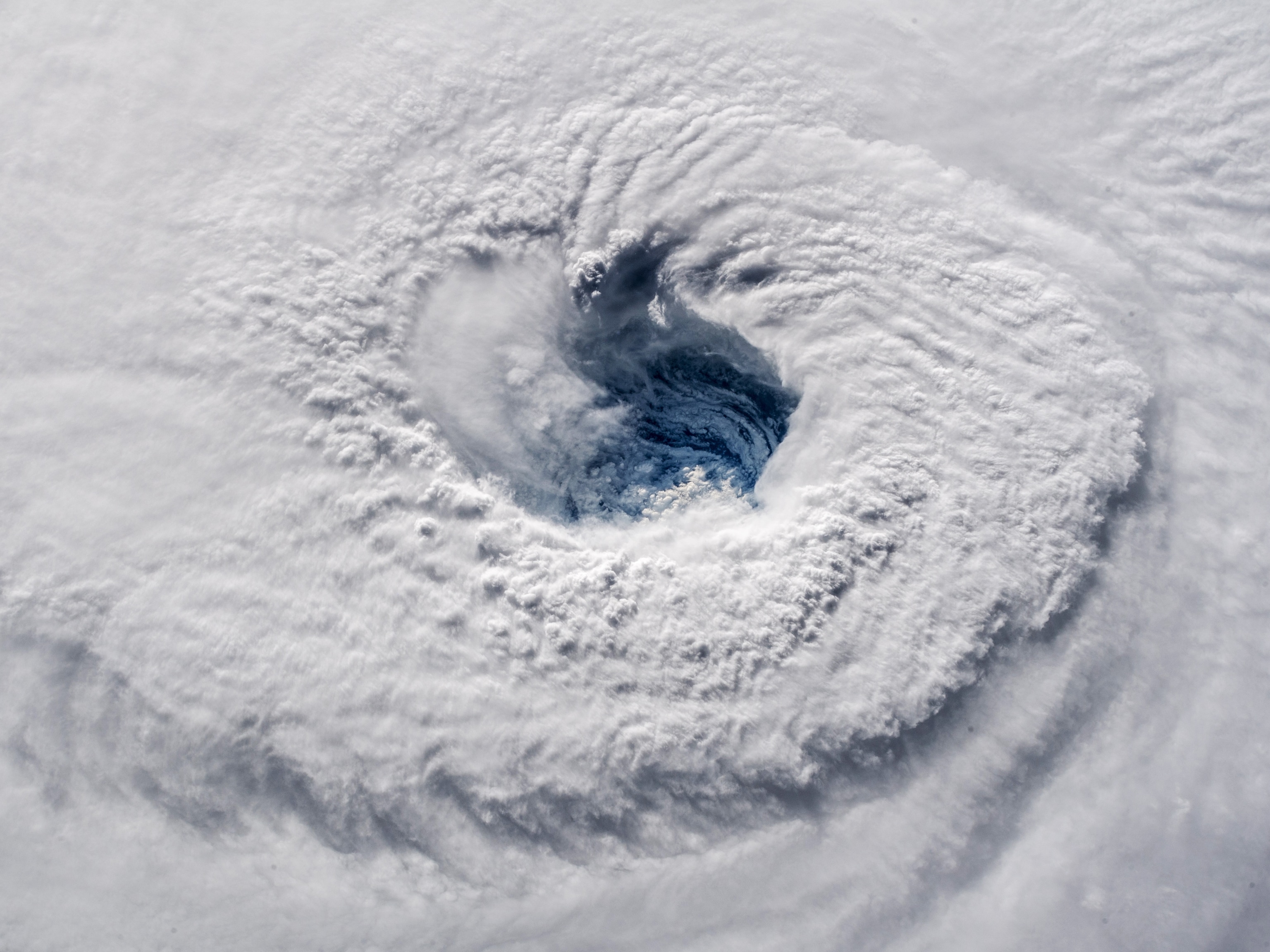
As oceans grow warmer, they’re creating conditions that allow hurricanes to undergo rapid intensification—when a hurricane’s wind speed increases by 35 mph or more within 24 hours. Hurricanes Milton and Helene are the latest examples of this phenomenon. Before Hurricane Helene struck Florida on Sept. 26, it grew from a Category 1 hurricane to a major Category 4 in just the span of a day. Now, Hurricane Milton is the next storm to follow the trend. Forming into a tropical storm on Saturday, the hurricane is now a Category 5 on a path to hit central Florida on Wednesday.
These types of explosive jumps have become more common in recent years, with devastating consequences.
On the morning of October 24, 2023, Tropical Storm Otis was heading for the Pacific coast of Mexico. Later that day, it was a major Cat-5 hurricane that would eventually slam Alcapulo with 165 mph winds.
The prior month, Hurricane Lee, a major hurricane currently traveling up the Atlantic, meteorologists observed the third-fastest case of rapid intensification ever recorded. On September 7, wind speeds inside Lee more than doubled, boosting it from an 80 mph Cat 1 storm to a terrifying 165 mph Cat 5 storm.
Rapid intensification only crops up in a handful of tropical cyclones each year. However, a study published last year in Nature found that, within 240 miles of coastlines, rapidly intensifying storms are now significantly more common than they were 40 years ago. Examples include Hurricane Ian in 2022 and Hurricane Michael in 2018. The latter leapt from a Category 2 storm to Category 5 the day before making landfall in the Florida panhandle. It claimed dozens of lives and caused $25 billion in damage.
And while some hurricanes intensify over open water, those that grow rapidly before striking landfall pose a major risk to people living on the coast. In such a situation, evacuations ordered under the expectation of, say, a Category 2 or 3 storm could prove wholly inadequate, leaving thousands of people vulnerable—a meteorologist’s worst nightmare.
Large, major storms like Milton and Helene also threaten people further inland; as Helene moved north, it caused catastrophic flooding over North Carolina and parts of the U.S. southeast.
Until very recently, it’s been difficult to forecast rapid intensification, which can emerge suddenly, partly because so many shifting conditions need to align in order to trigger it. Plus, much depends on activity in the very core of the hurricane, from where it is notoriously difficult to gather data. Scientists are now developing new methods to help them warn people of this rising threat.
Recipe for a hurricane
The development of any hurricane relies on the right environmental conditions. If water in the ocean beneath the hurricane is warm enough, it releases large amounts of energy as it evaporates, which in turn creates a dip in air pressure that whips up powerful winds.
The strengthening system also benefits from surrounding humid air, which locks moisture and energy inside the hurricane itself. Low vertical wind shear, where winds at higher altitudes remain relatively low in speed, also help the hurricane maintain its power.
But what is it about all these conditions that makes the difference between a gradually strengthening storm and one that intensifies rapidly?
“Everything just has to align,” says Brian Tang, an atmospheric scientist from the University at Albany. All those conditions developing simultaneously help to trigger rapid intensification.
Just before Hurricane Lee’s sudden explosion in power, Tang had a hunch things were about to escalate—thanks to images of the swirling mass of ice crystals and rainwater inside the hurricane.
“It was very symmetric,” recalls Tang. “That signature was like, ‘Oh yeah, this is about to really jump up in intensity’.”


It wasn’t just Tang who had an inkling that Lee was about to become significantly more powerful. He notes that models such as the Hurricane Analysis and Forecast System (HAFS) at the National Oceanic and Atmospheric Administration (NOAA) actually predicted rapid intensification for this hurricane around 24 hours in advance.
Yet there were still surprises, says Jason Dunion, a meteorologist and director of NOAA’s Hurricane Field Program. “I think it was pretty clear to me and other forecasters that we would see rapid intensification—that 35 mph in one day,” he recalls. “But it was much faster than that.”
By gathering more data from the inner core of a hurricane ahead of time, including via the Hurricane Hunter reconnaissance flights that Dunion and his colleagues make, these models could perhaps be even more accurate at predicting the degree of rapid intensification that will occur.
More detailed measurements are helping forecasters, too. Take 2018’s Hurricane Michael. A 2020 study found that satellite data and readings from buoys in the Gulf of Mexico, for example, showed a marine heatwave was underway during its approach. Similar data could warn meteorologists in the future that an incoming hurricane is about to intensify.
Additionally, researchers are increasingly flying drones into the little-studied lower and most dangerous part of a hurricane, called the boundary layer, in order to gather useful information about how storms intensify.
Getting into hot water
Ruby Leung, an atmospheric scientist at the U.S. Department of Energy’s Pacific Northwest National Laboratory, points out that the influence of the ocean on tropical cyclones can be complex. If, for example, a lot of freshwater flows from a river into the ocean, you can get an upper, fresher, layer of warm water above the denser, saltier water below. That makes it much harder for a storm to mix the ocean and bring cooler deep water to the surface. If those upper waters remain warm, a hurricane can continue to strengthen.
This effect supercharged Hurricane Irma in 2017. “It rapidly intensified exactly at the time when it passed over this area with very fresh water at the surface of the ocean,” says Leung.
She and colleagues published a study in 2020, in which they showed how freshwater from the Amazon-Orinoco river system appears to increase the chances of rapid intensification in the eastern Caribbean and western tropical Atlantic.
A similar ocean layering occurs when hurricanes produce especially high amounts of rainfall, which also adds a surface layer of freshwater to the ocean, making it harder to mix. There are already signs that climate change-induced freshening from increased rainfall in the North Pacific, for example, is intensifying typhoons—the equivalent of hurricanes in that region.
Hurricanes, and storms in general, are producing more rainfall as air temperatures rise, adds Leung, increasing the odds of intensification and creating a kind of feedback loop.
Henry Potter, an oceanographer at Texas A&M University, has studied how Hurricane Harvey rapidly intensified back in 2017 as it reached the Texas Bight, a region of coastal waters in the Gulf of Mexico. One measure of the heat energy available to the storm suggested the risk of rapid intensification was relatively low. But it didn’t account for the fact that the water was warm all the way down.
“It doesn’t matter how much mixing you do, you’re not going to be mixing up any cold water,” explains Potter.
Research indicates that populated areas are going to be more exposed to hurricanes in the near future. For example, First Street Foundation estimates that a significant proportion, around 40 percent, of the population in south-eastern Michigan is potentially unaware of a heightened flood risk in their area due to increased rainfall, including from hurricanes.
The overall range of tropical cyclones is also expected to widen significantly, meaning millions more people could face the devastating effects of these mammoth storms, and rapid intensification specifically, in the years to come.
“It is a major concern,” says Potter. “The inevitability here is that the oceans are just going to become like bathwater in the summer—deep baths that are great for storms to intensify.”